Phu Quy itinerary: how to spend 1, 2 or 3 days

This plan suits a slow stay on a fishing island with one ring road, where a rented scooter takes you anywhere in a quarter of an hour. It starts from the morning boat: sleep in Phan Thiet the night before, since the boats leave between about 05:00 and 11:30 depending on the tide. Day 1 stays around Tam Thanh, the port town; Day 2 is a scooter loop to the lighthouse, the temples of the north and the sunset on Cao Cat; Day 3 is a canoe trip to the Hon Tranh islet. Come in March or April for the calmest sea and the driest weather. From November to March the north-east wind can stop the boats for days, so keep a spare day before any flight home.

On this page

How many days

  • 1 day: Day 1

    One day covers the whale temple, Tam Thanh market, the island's oldest pagoda and an afternoon at Trieu Duong bay, and leaves out the north of the island and the islets.

  • 2 days: Days 1 to 2

    Two days add a scooter loop: the lighthouse, the wind turbines, the temples of the north, a swim at Bai Nho and the sunset from Cao Cat.

  • 3 days: Days 1 to 3

    Three days add a canoe to the Hon Tranh islet for snorkelling, then the Lang Duong fish pond and the flagpole headland.

Day 1

Tam Thanh, the whale temple and Trieu Duong bay

Off the morning boat, the whale skeleton at Van An Thanh a few steps from the pier, the market, the island's oldest pagoda, and an afternoon swim with the islanders at Trieu Duong bay.

09:00 to about 18:30 · 6 stops

123456500 m
Numbers follow the plan below; solid lines by road, dotted on foot, dashed by boat, train or cable car. Map: © OpenStreetMap contributors, Natural Earth.
  1. 09:001

    Travel · 30 min

    Phu Quy port

    The boat from Phan Thiet lands at the port in Tam Thanh, the main town, after about two hours at sea. Have your passport in hand: the border guard post at the port checks everyone who comes ashore. Scooter renters and guesthouse owners wait at the gate holding name boards, so arrange your pickup or your scooter the day before. The market is next door, and the whale temple is a short walk along the waterfront.

    About 5 min walk, 0.4 km. About 400 m along the waterfront to Van An Thanh.

  2. 09:452

    Sight · 45 min

    Van An Thanh whale temple

    Cost: No fee published; phone ahead, as it is not always open.

    In 1941 a whale washed up on Phu Quy, and the islanders buried it with a full funeral. Its skeleton, about 20 m long, is kept here, with incense burning by the jawbone. Fishermen along this coast worship the whale as a protector, and islanders still tell of whales guiding boats through storms. Van An Thanh is one of the island's two national historical and cultural relics. The tourism authority advises phoning ahead, because the temple is not always open.

    About 5 min by motorbike, 0.8 km. About 1 km through town to the market.

  3. 11:003

    Market · 1 h 30 min

    Tam Thanh market and lunch

    Cost: Prices on the stalls; a Bao Da Nang reporter was told islanders and visitors pay the same.

    The market in Tam Thanh is the place for lunch and for juice pressed from wild pineapples picked on the island, which a Bao Da Nang reporter drank here in 2026, eating until full and being handed a few more on leaving. Stallholders kept telling the reporter that everything costs the same whether you are an islander or a tourist. Look for dried squid to take home, and ask about hot beef, bo nong, from cattle raised on the island and sold the day they are slaughtered.

    About 5 min walk, 0.5 km. About 500 m north to Linh Quang pagoda.

  4. 13:304

    Sight · 45 min

    Linh Quang pagoda

    Cost: Free; dress modestly.

    Linh Quang is the oldest temple on Phu Quy and, with Van An Thanh, one of its two national historical and cultural relics. It is a working pagoda, so dress modestly and keep your voice down if a service is on. The Bao Da Nang reporter met a woman at a service here who drove the reporter to an elderly islander's house to ask about the island's past, then waited to bring the reporter back to the hotel.

    About 5 min by motorbike, 1.9 km. About 2 km east to Trieu Duong bay.

  5. 15:005

    Do · 2 h 30 min

    Trieu Duong bay

    Cost: Free.

    About a kilometre from the port, Trieu Duong is a wide stretch of white sand backed by casuarina trees, with clear blue water. Islanders come to swim in the afternoon, which is the time to join them. The trees give shade for a long rest, and the tourism authority suggests a picnic. Leave the scooter on the road above; the last stretch to the sand is on foot.

    About 5 min by motorbike, 1.9 km. About 2 km back to Tam Thanh.

  6. 18:306

    Eat · 1 h 30 min

    Dinner in Tam Thanh

    Cost: Seafood is priced by weight; ask before it is cooked.

    Phu Quy lives on fishing, so dinner is seafood: grouper, squid, lobster and the island's two prized crabs, the king crab and the moon crab, named for the round red spots on its shell. Both crabs are hard to catch, so ask your guesthouse to order them a day ahead. VnExpress also names restaurants on rafts moored off the island, which cook what the boats bring in. If you want something else, try the hot beef.

Day 2

A scooter loop: the lighthouse, the north and Cao Cat at sunset

The lighthouse and the wind turbines while it is cool, the Cham princess's temple and the Chinese healer's tomb in the north, a long lunch, a swim at Bai Nho, and the sunset from Cao Cat above Linh Son pagoda.

07:00 to about 19:00 · 8 stops

123456782 km
Numbers follow the plan below; solid lines by road, dotted on foot, dashed by boat, train or cable car. Map: © OpenStreetMap contributors, Natural Earth.
  1. 07:001

    View · 1 h

    Phu Quy lighthouse

    Cost: Free; a small donation to the keepers is welcome.

    The lighthouse stands on Cam mountain, more than 100 m above the sea, at the end of the road up past Linh Buu pagoda. Ride to the foot of the hill and walk the last stretch, about 200 m. From the top you see the whole island and the open sea on every side. Entry is free, and the tourism authority asks visitors to leave a small donation towards the upkeep. Go early, before the heat and the wind pick up.

    About 5 min by motorbike, 1.4 km. About 1.5 km north to the wind turbines.

  2. 08:302
    A wind turbine of Phu Quy's wind farm beside a roadside shelter near the sea

    View · 30 min

    The wind turbines

    Cost: Free; seen from the road.

    Three white turbines, 6 MW in all, have stood here since 2012, when PV Power began selling their electricity. Before them the island ran on a diesel plant that gave power only 16 hours a day. An engineer quoted by EVN called Phu Quy the best island in Vietnam for wind, with an average speed over 10 metres a second, and you will feel it here. They are a popular photo stop; VnExpress suggests walking round them to find a better angle.

    Image: Theodore Nguyen / Pexels

    About 5 min by motorbike, 2.9 km. About 3 km east to the Ban Tranh temple.

  3. 09:153

    Sight · 30 min

    Temple of Princess Ban Tranh

    Cost: Free; dress modestly.

    The Cham built this temple towards the end of the 15th century for a Champa princess. The legend says she refused a forced marriage, was set adrift by the king, and landed on Phu Quy, where she stayed to farm and helped the islanders fight off foreign invaders. After her death they built her a shrine and called her Ba Chua Xu, the lady of the island, and a ceremony still marks the anniversary of her death each year.

    About 5 min by motorbike, 2.3 km. About 2 km east to Dinh Thay Nai.

  4. 10:004

    Sight · 45 min

    Tomb of Master Nai

    Cost: Free; dress modestly.

    The islanders worship Thay Nai as the island's guardian. The story told about him is that he was a Chinese merchant who knew medicine, was blown onto Phu Quy by a storm, stayed for the rest of his life to treat the sick, and was buried here in 1665. Islanders come to pray when times are hard or when the fishing goes well, and they hold his ceremony each year on the fourth day of the fourth lunar month.

    About 10 min by motorbike, 5.1 km. About 5 km back to Tam Thanh.

  5. 11:305

    Eat · 2 h 30 min

    Lunch and a rest in Tam Thanh

    Cost: Local eateries; prices on the board or ask first.

    Head back to town for lunch and a rest through the hottest hours. The Bao Da Nang reporter's list of island food included squid and shrimp cakes, fish cake noodle soup, stingray salad, grilled needlefish and a fish hot pot, along with the hot beef. The wind is strong all day, so keep hats and bags tied down on the scooter. VnExpress says one full tank of fuel is enough to ride all over the island.

    About 5 min by motorbike, 2.9 km. About 3 km east to Bai Nho and Ganh Hang.

  6. 14:306

    Do · 2 h

    Bai Nho beach and Ganh Hang

    Cost: Free.

    Bai Nho is a crescent of white sand between rocky headlands on the east coast, with water clear enough to see the bottom and few boats, so it is safe for swimming and snorkelling. Leave the scooter on the road and walk down the path. A few hundred metres north is Ganh Hang, a cliff where the waves fill a rock pool people call the infinity pool. Wear shoes that grip, stay back from its seaward edge, where waves can pull you out, and go with a local if you can.

    About 10 min by motorbike, 4.9 km. About 5 km round to Linh Son pagoda in the north.

  7. 17:007
    Red steps flanked by golden dragons climbing to the gate of Linh Son pagoda on Phu Quy

    View · 1 h 30 min

    Cao Cat and Linh Son pagoda at sunset

    Cost: Free; the pagoda asks for modest dress.

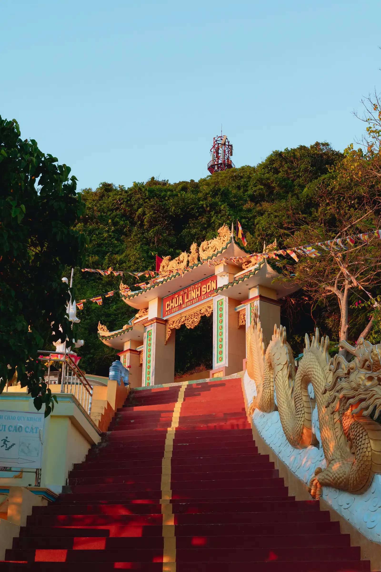
    Climb the steps to Linh Son pagoda, founded in 1848, then take the path on to the top of Cao Cat, 106 m, one of the peaks left by the volcano that made the island. Weathering has cut its grey rock into ledges that islanders compare to the Grand Canyon. A Bao Da Nang reporter made this climb at sunset in a strong wind, with the whole island and its three white turbines spread out below.

    Image: Theodore Nguyen / Pexels

    About 10 min by motorbike, 5.2 km. About 5 km back to Tam Thanh in the dark; ride slowly.

  8. 19:008

    Eat · 1 h 30 min

    Dinner in Tam Thanh

    Cost: Seafood is priced by weight; ask before it is cooked.

    Back in town, this is the night for the crabs if you ordered them the day before, or for lobster, which the islanders have long caught here. The tourism authority also suggests the local wine made from screwpine fruit, ruou dua, which grows wild across the island, and dried squid to take home. Ask your guesthouse to book the canoe to Hon Tranh for the morning, and ask them about the next day's wind before you pay.

Day 3

Hon Tranh by canoe, the fish pond and the flagpole

A morning canoe to the Hon Tranh islet for snorkelling and fishing, lunch back in town, then the old stone fish pond at Ganh Hang and the flagpole headland above Bai Nho.

07:30 to about 16:00 · 4 stops

12341 km
Numbers follow the plan below; solid lines by road, dotted on foot, dashed by boat, train or cable car. Map: © OpenStreetMap contributors, Natural Earth.
  1. 07:301

    Do · 3 h

    Canoe to Hon Tranh

    Cost: About VND 250,000 a person without lunch in VnExpress's guide; agree the price through your guesthouse.

    Hon Tranh is about 10 minutes by canoe from the main island, and locals count it, with Hon Den, among the prettiest and safest islets to visit. A canoe trip usually includes fishing, snorkelling over the coral, photo stops and lunch on a fish farm raft, where your catch can be prepared as raw fish. Your guesthouse can find a boat and a guide; ask them the evening before whether the sea will be calm enough.

    By boat, 3 km. About 10 minutes back across to the main island.

  2. 11:002

    Eat · 2 h

    Lunch in Tam Thanh

    Cost: Local eateries; prices on the board or ask first.

    If you did not eat on the raft, lunch is in town. Try something you missed: the hot beef, a fish noodle soup or the moon crab, which needs ordering a day ahead. VnExpress's guide says May is the peak season for seafood on the island, when shrimp, crab, fish and snails are plentiful and sell at low prices. Rest through the early afternoon, when the sun is strongest, and refill the scooter's tank.

    About 5 min by motorbike, 3.6 km. About 3.5 km east to the Lang Duong fish pond.

  3. 14:303

    Sight · 1 h

    Lang Duong fish pond

    Cost: Free.

    Islanders built stone walls here to pen the sea, with round holes spaced along them that let the water in but keep fish and shrimp from getting out. The pond has long been abandoned and works now as a kind of open aquarium. Walk along the low walls to look for small fish and other sea life in the pools, or sit with your feet in the calm water. Watch your footing on the wet stones.

    About 5 min by motorbike, 0.6 km. About 600 m south to the flagpole.

  4. 16:004
    The flag on a headland above a sandy cove and black volcanic rocks on Phu Quy

    View · 1 h

    The flagpole above Bai Nho

    Cost: Free.

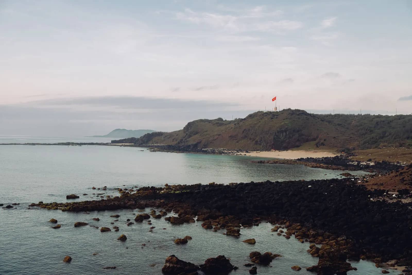
    The national flag flies from a 22.6 m concrete pole on the headland above Bai Nho beach, the spot nearly every visitor to the island photographs. Below it, dark volcanic rock runs down to a sandy cove. Come in the late afternoon, when the light is softer, and walk down to Bai Nho for a last swim if you have time, keeping to the beach rather than the rocks when the waves are up.

    Image: Theodore Nguyen / Pexels

Tips for Phu Quy

  • Sleep in Phan Thiet the night before: the boats leave between about 05:00 and 11:30, set by the tide, and the port board publishes the month's times in advance.
  • Bring your passport and a valid visa: a border guard post checks ID at Phu Quy port, and the name on your e-ticket has to match it. Foreigners have needed no permit since September 2020.
  • From November to March the north-east wind can stop the boats for days, so keep a spare day before any flight home and take a seasickness tablet before the crossing.
  • There are no taxis on the island in VnExpress's guide: rent a scooter from your guesthouse, at VND 100,000 to 120,000 a day by its figures, or ask your host for a car.
  • ATMs are scarce, so bring enough cash from Phan Thiet.
  • Order king crab or moon crab a day ahead through your guesthouse; both are hard to catch.
  • March and April are the best months: the driest, sunniest weather and the calmest sea.

Getting there, where to stay and the weather by month are on the Phu Quy page. Plan checked 27 October 2026.

Sources

Checked in October 2026.Show all 12 sources
  • cangvuhanghaibinhthuan.gov.vn. Boats from Phan Thiet leave at hours set by the tide, between about 04:45 and 11:30 in November 2026; the port board publishes each month's timetable (place-phu-quy rows 5 and 27).
  • phuquocexpress.com. Border guard post at Phu Quy port checks ID; foreigners need passport and valid visa, no special permit; scooter renters and guesthouses wait at the port gate; market next to the port; Van An Thanh's whale skeleton a short walk away (place-phu-quy row 26).
  • vnexpress.net. Van An Thanh: whale washed ashore in 1941 and buried with a funeral; skeleton over 20 m; whales believed to help boats in storms (VnExpress); incense by the jawbone, phone ahead (tourism authority); national relic (Bao Lam Dong) (place-phu-quy rows 2, 17, 23).
  • vietnam.travel. Tourism authority: incense near the whale's jawbone; the museum is not always open, phone ahead; Trieu Duong bay long, wide white sand backed by casuarinas, shade for a picnic; Lang Duong pond abandoned, an informal aquarium, walk the low walls; lighthouse free, leave a donation; king crab and moon crab hard to catch; lobster catching a long tradition; pineapple wine (ruou dua) from screwpine growing across the island; dried squid to take home; grouper and squid.
  • vietnam.vn. Bao Da Nang reporter, October 2026: wild pineapple juice at Tam Thanh market, given more on leaving; "same price" for islanders and tourists; at Linh Quang, the oldest temple, a woman drove the reporter to an elderly islander's house and back; food list (squid and shrimp cakes, fish cake noodle soup, stingray salad, grilled needlefish, hot pot, hot beef); Linh Son pagoda founded 1848, climb to Cao Cat at sunset in strong wind, three white turbines below (place-phu-quy rows S1 to S5).
  • baolamdong.vn. Linh Quang pagoda and Van An Thanh are the island's two national historical and cultural relics (place-phu-quy row 23).
  • e.vnexpress.net. VnExpress International: Trieu Duong, locals swim in the afternoons, clear blue water; Bai Nho crescent beach, park on the road and walk down a trail; Ganh Hang infinity pool, wear sturdy shoes, keep away from the edge; Cao Cat 106 m on the north side, Linh Son on the way; lighthouse on Cam mountain at 100 m, open, free, donation; Princess Ban Tranh temple built by the Cham at the end of the 15th century, the legend, Ba Chua Xu; Master Sai Nai, Chinese merchant with medicine, storm, died 1665, ceremony on the 4th day of the 4th lunar month, islanders pray for luck and a good harvest; Lang Duong pond abandoned; canoe 10 minutes to the islets; Hon Tranh and Hon Den beautiful and safe, tours with fishing, coral, photos, lunch at a raft house, catch made into raw fish dishes, VND 250,000 a person without lunch, ask the hotel; May the peak season for seafood.
  • evn.com.vn. Wind turbines: three turbines, 6 MW, operating from 2012 (EVN); PV Power started commercial operation on 25 August 2012; diesel plant 16 hours a day before; Phu Quy the best island for wind, average over 10 m/s (place fun fact phuquy-wind).
  • openstreetmap.org. Coordinates from OpenStreetMap (Overpass): Phu Quy port node 9469372316 (10.502929, 108.951314); Van An Thanh way 1015158479 (10.504761, 108.951248); Tam Thanh market way 1176839553 (10.506716, 108.945634); Linh Quang pagoda way 1014986358 (10.510381, 108.944943); lighthouse way 1272966038 (10.539341, 108.933156); wind turbine node 5573888849 (10.545648, 108.923606); national flagpole node 9365035799 (10.511804, 108.9659), the only national flagpole mapped on the island, beside Bai Nho; beach on Hon Tranh way 486600077 (10.487429, 108.964742).
  • google.com. Coordinates from Google Maps places (checked against Wikimapia or a Google Maps embed on vinpearl.com): Linh Son pagoda 10.54615, 108.94837 (Wikimapia 7463279, 29 m away); Cao Cat summit 10.54659, 108.94783 (same place as vinpearl's embed); Ganh Hang 10.51595, 108.96658 (identical to vinpearl's embed); Bai Nho 10.51214, 108.96647 (OSM beach way 486600090, 65 m away); Trieu Duong bay 10.50506, 108.96081 (Wikimapia 31907208, 65 m away); Thay Nai tomb 10.54599, 108.95618 (Wikimapia 26883603, 20 m away); Ban Tranh temple 10.54702, 108.94435 (Wikimapia 22679684, 7 m away); Lang Duong pond 10.51731, 108.96593 (vinpearl: 150 m from Ganh Hang).
  • vinpearl.com. Cao Cat lies in the north of the special zone, formerly Long Hai commune, about 3 km from the old town centre (vinpearl); Ganh Hang is in the south-east of the island (vinpearl).
  • router.project-osrm.org. OSRM legs (no traffic): port to Van An Thanh 396 m; Van An Thanh to Tam Thanh market 828 m; market to Trieu Duong 1.9 km; lighthouse to turbine 1.4 km; turbine to Linh Son 3.9 km; Thay Nai to Ban Tranh 2.3 km; built day maps (data/itinerary-maps/phu-quy.json): turbine to Ban Tranh 2.9 km, Thay Nai to Tam Thanh 5.1 km, Tam Thanh to Bai Nho 2.9 km, Bai Nho to Linh Son 4.9 km, Linh Son to Tam Thanh 5.2 km, Tam Thanh to the pond 3.6 km, pond to the flagpole 0.6 km; port to Linh Son 6.1 km, 11 min; the lighthouse, Ganh Hang, Bai Nho, Trieu Duong and the pond are 118 to 211 m from the nearest mapped road.